Date:08/15/2011
Hikers:Frank, Matt, Me
Peaks:Dix Mtn (4857') (#6), Hough Peak (4400') (#23)
Trailhead:Elk Lake Trailhead
Trip Time:9 Hours (20 minutes on each summit)
I retired early for the night because I wasn't feeling so well. I set the alarm for a 4:30 wakeup, our agreed upon time with the hopes that we would be back at the campsite by five to make dinner, relax down by the lake, do some fishing and just enjoy the evening. The forecast was calling for rain all day but we were hopeful that it would hold off or just be spotty at times. We woke up at 4:30 to the sound of rain on our tents and tarps. We downed some oatmeal with a banana along with coffee and juice; we didn't eat that well in our leanto last year. By 5:15 we were leaving the site and heading to the Elk Lake Trailhead.
Elk Lake is a small parking area because it's located on private land. We arrived shortly before 6:00 with the rain still coming down pretty steady. We were thinking the weather was deterring people from hiking because there was not one other car in the parking lot. Matt signed us into the register and we began the trek down the Hunter Pass Trail in our attempt of conquering the Dix range. We were going to do the Dix Range Traverse going from Macomb – East Dix – South Dix – Hough – Dix.
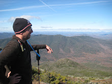
 |
| Me, Frank, Matt |
The hike in was wet, with all the rain throughout the night it was all heavily saturated. We knew we were going to hike into the Slide Brook leanto and then start our ascent of Macomb Slide up to Macomb. We crossed over the bridge right before the Slide Brook leanto, which was empty. We had a light snack and started to comb the grounds for the cairn. There were a bunch of small trails around the leanto but nothing w/ a cairn. So we thought maybe the map was off a little. We continued down the Hunter Pass Trail with hopes of finding the cairn. Shortly thereafter (roughly about ½ mile) we realized that we definitely passed the cairn. By this point we revisited the map and made a decision that heading back would only put us behind. So we were going to switch up the hike and go clockwise. We were going to climb the Beckhorn to Dix first.
 |
| Frank Crossing Slide Brook |
About another ¼ mile down the trail we ran into a couple that was lost. They had gotten lost the night before and ended up spending the night on the summit of Dix. They had entered the Range from Route 73. Since we were closer to Elk Lake we directed them in that direction in hopes there would be someone to give them a ride back. They felt comfortable with our directions and we parted ways.
 |
| Slide Brook |
Shortly after, we reached the cairn for the Beckhorn trail. For a moment the relief was setting in that we were finally on the right path. The Beckhorn sounds like an intimidating name and when you are sick, wet, and just won't stop raining this felt like the worst hike ever. The trail continued up for what seemed forever. However, if you talk to Frank and Matt, it might not have been as bad as I remembered it. I was dragging ass most of the day anyway.
 |
| Frank, Matt, Me on Dix Summit |
After what seemed like a climb that took several hours, we reached the summit of Dix at 11:45. There was a group on the summit that had hiked in from Route 73 and they confirmed that we were on the summit. Visibility was about 20-30 feet and we were soaked. We didn't take much of a break and just decided to head on. The group pointed us in the direction of the herd path we were looking for and on we hiked.
The herd path was so narrow and the underbrush had retained so much water that the rain water from the brush was rolling down our pants and into our boots. We would switch back and forth of who was leading because the person in first would get the worst of it. We came to an opening and couldn't find any markers so we assumed we were on the Summit of Hough and snapped a pictured. Still with no visibility and nothing around us to verify that we were on the summit, we continued down the herd path further. After about 30 minutes we came to a second opening and snapped a picture because we thought we were at South Dix. We didn't see any additional herd paths to point us in the direction of East Dix so we continued on the same herd path, where finally we came upon a campsite. Now we were officially confused. We hung out for a little bit and decided before continuing farther down a path we were uncertain of, our best bet would be to just head down hill.
 |
| Me, Frank, Matt on Hough Peak Summit |
We started downhill and after about 10 minutes we ran into a group of 4 (1 Adult & 3 kids). We started to tell them of our hike and the man stated that we never reached the summit of South Dix but we definitely hit the summit of Dix and Hough. He described to us what the summit of Hough looked like so we figured out that we reached the summit of Hough at 12:30. The campsite that we just left was the Lillian Brook campsite and we were currently on the Lillian Brook Trail. He told us it would be better to come back another day to do Macomb because the views are beautiful up on the summit and it was a horrible day to hike up on Macomb. I felt like garbage and had no objection to coming back again, so we continued down the Lillian Brook trail to Hunters Pass and straight back to the car.
 |
| The Empty Parking Lot |
We reached the car at 4:00 and went back to the campsite. We had talked about packing up that night and just heading home but I wasn't motivated to do all that. By the time we reached the campsite and tried to dry off, the rain started to really come down hard. At this point I was finished. We all agreed to pack it up and head home. We packed up, hit the showers to warm up, and headed into Schroon for a bite to eat. We stopped at Pitkin's Restaurant for nice hot meal. The buffalo chicken soup and hot open face roast beef sandwich hit the spot for the conclusion of my epic failure of the Dix Range.


No comments:
Post a Comment